IMPACT OF THE 2020 CZU FIRE ON MARBLED MURRELET NESTING HABITAT IN BIG BASIN REDWOODS STATE PARK
Steven W. Singer, M.S.1
Consulting Forest Biologist
Alex Rinkert2
Consulting Biologist and Ornithologist
Report prepared for the Santa Cruz District, California State Parks
December 2025
Steven Singer Environmental & Ecological Services
Santa Cruz, CA. 95060
1 SWSingerMS@aol.com, 218 Nevada Street, Santa Cruz, CA. 95060
2 arinkert@gmail.com, P.O. Box 21, Santa Cruz, CA. 95062
Impact of the 2020 CZU Fire on Marbled Murrelet
Nesting Habitat at Big Basin Redwoods State Park
KEY FINDINGS
The 2020 CZU fire was an exceptionally severe crown fire. It was likely the most severe fire to burn the eastern half of Big Basin Redwoods State Park, hereinafter “Big Basin”, in the last 400 years. It burned through the entire park in only 12 hours, being pushed by high winds (Hyland 2022). Flame heights near the park headquarters area were reported to be up to 400 feet high (Spohrer 2021). It resulted in the loss of 78% of the potentially suitable marbled murrelet nest trees.
The 2020 fire caused major changes to the structure and composition of the old-growth coast redwood- Douglas-fir forest in the park. Douglas-fir was virtually eliminated from the park, being found now in only a few very small refugia. Murrelets favored Douglas-fir for nesting, but Douglas-fir suffered very high mortality immediately after the fire and additional mortality in the next three years.
To best comprehend the results of this study it is necessary to appreciate the unusual severity of this fire (Santa Cruz Mountains Bioregional Council 2020). It was the most severe fire to burn the park in the last 400 years as evidenced by the composition and age of Douglas-fir. One year after the fire, Mahdizadeh and Russell (2021) found that 85% of the Douglas-fir trees had been killed by the fire.
However, this is an under-estimate since many additional Douglas-fir trees were later removed in the hazardous tree removal program (Singer, pers. obs.). A long interval free of high intensity crown fires is indicated by the fact that prior to this fire there was a significant cohort of 350 - 400 year-old Douglas-firs in the park and almost all of these were killed by the fire (Mahdizadeh and Russell 2021, Singer, unpub. data).
Most of the park burned at an extreme or high severity level and refuge areas that were unburned or lightly burned within the east half of the park comprised less than 100 acres in total (see fire severity imagery in Potter et al. 2023, Pacific Seabird Group 2025). The extreme severity of the 2020 CZU fire was driven by the weather and climate variables associated with global warming and not fuel build up in the understory (Safford et al. 2021). The extreme severity of climate change megafires, like this one, pose a significant threat to the remaining nesting habitat of the marbled murrelet throughout its breeding range from Washington to California and hence to the survival of the species (Pacific Seabird Group 2024a).
METHODS
Prior to the CZU fire, the senior author found and mapped the location of 107 potentially suitable nest trees, hereinafter referred to as PNTs, at Big Basin. These same trees were monitored after the fire over a three year period to see if they still qualified as PNTs.
Research Area
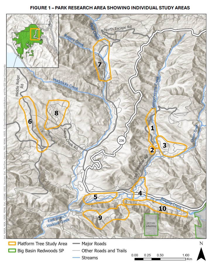
The research area for this study is the “basin” part of Big Basin Redwoods State Park, which is approximately the east half of the park, and contains ten smaller individual study areas. The research area is about 2600 acres in size and contained primarily old-growth coast redwood-Douglas-fir forest but also contained lesser amounts of young-growth redwoods, mixed evergreen forest, and chaparral. Its margins conform closely to the map margins found in Figure 1 in the Appendix. For a more detailed description of the research area see Singer (2025).
The research area is known to be an important nesting area for murrelets which are a federal/state threatened/endangered species (Pacific Seabird Group 2024b). Of 13 murrelet nests found in the park, 12 have been located within this area (Halbert and Singer 2017, Rinkert 2021). Most dawn and dusk murrelet flight activity also occurs within this area, prompting murrelet monitoring efforts to be focused therein (Halbert and Singer 2017).
Potential Nest Tree (PNT) Identification
All potentially suitable murrelet nest trees (PNTs ) that occur within the Santa Cruz Mountains are either coast redwood or Douglas-fir and have a relatively flat “platform” formed by either a large branch or a broken-top tree (Baker et al. 2006). Additionally, any potential nest site must be at least 33 feet (10m) high and be within the live crown of the tree, or, if a broken-top tree top is providing the platform, have at least some green foliage associated with it (Pacific Seabird Group 2024, Halbert and Singer 2017). We used 8 inches (20 cm) as a minimum platform size even though the Pacific Seabird Group (2024b) recommends a minimum platform size of 4 inches (1.75 cm). We did so because the smallest nest platform found in the Santa Cruz Mountains to date was 11 inches (28 cm) in diameter (Baker et al. 2006).
Monitoring of PNTs
Between 2012 and 2014, the senior author identified and mapped 107 PNTs within the areas of old-growth forest in the research area (see Figure 1 in Appendix). Most of the ten study areas were visited intermittently by the senior author in subsequent years and all PNTs were believed to be still present in 2020, as no major disturbance events had occurred during that period.
The post-fire condition of PNTs in Areas 1–5 was assessed in November 2020, and Area 6 was assessed in May 2021 (Table 1 in Appendix). In spring 2022, Areas 1–6 were reassessed, and in fall 2022, Areas 8–10 were assessed for the first time by the junior author (Table 1 in Appendix).
On the initial assessment of each area, the fire severity rating (low, moderate, high, extreme) was determined using a burn index scale specifically developed for the CZU fire in Big Basin since its severity was not adequately represented by the existing rating systems (Singer 2023).
On each visit, the status of all PNTs trees was recorded. A tree was considered to be a PNT if it contained at least one suitable platform on a branch or broken top with suitable cover, and a portion of the original live crown was still present. PNTs were considered lost if any one of the following conditions were observed: a) the tree was no longer present, b) the tree was present but would soon die, c) the tree lacked a suitable platform, or d) a platform was present but it lacked suitable cover.
We continued monitoring for three years after the fire because we felt that there was a significant risk of delayed tree mortality or branch failure. We observed branch failures in each of the three winters following the fire. Besides fire, high winds are a major source of mortality for old-growth redwoods as basal hollows enlarged by fire can weaken the structural integrity of a tree (Norman n.d.). Additionally, the Park Department’s hazardous tree removal effort, which we suspected might remove some PNTS, continued until the summer of 2023 (Singer, pers. obs.).
FINDINGS
The 2020 CZU fire did major damage to murrelet nesting habitat in the Santa Cruz Mountains. Coast redwoods lost all their large branches to the fire. Although new branches will sprout from the bole, it will take hundreds of years for them to become as large as the original branches were and thereby provide a suitable nest platform for murrelets (Singer 2025). Almost all old-growth Douglas-fir in the research area were killed by the fire with the exception of trees within the few small refugia areas (Mahdizadeh and Russell 2021).
Results of the PNT monitoring effort are shown in Table 1. Only 23 of the original 107 PNTs survived the fire and associated events that occurred afterwards. That is a survival rate of just 22%. Broken down by species, 16 of 40 redwood PNTs survived (40%) and 7 of 64 Douglas-firs survived (11%). Douglas-firs were never common in the park but were favored for nesting by murrelets. A previous study by the State Parks Department in 1956 of the size-class distribution of old-growth redwoods and Douglas-firs in our research area found the composition of the two dominant trees to be 74% redwood and 26% Douglas-fir (California Div. of Beaches and Parks,1956, Singer unpub. data). Many of these Douglas-firs provided suitable nest platforms for murrelets, and in fact, were the favored tree for nesting in the park by about 2:1 over redwoods based on the percentage of known nest trees that were Douglas-fir (Baker et al. 2006) and the relative availability of old-growth Douglas-fir trees in the park.
The greatest loss of PNTs occurred, as expected, in the study areas that had high to extreme severity fire which were study areas 1 -3 and 7-10. There was only 12% PNT survival in these areas. Also not surprising, there was 46% survival of PNTs in the areas with low to moderate burn severity (areas 4, 5, and 6). Douglas-fir was more vulnerable to fire than coast redwood. Mahdizadeh and Russell (2021) found only 15% survival rate for Douglas-firs greater than 1.75 inches (4 cm) dbh. In our study areas with high-extreme severity only 4% of the Douglas-fir PNTs survived. Survival was still low, but less so, in our low-moderate burn study areas with a value of 25%.
DISCUSSION
The validity of our conclusions is dependent on how well the tree composition in our study areas represents the overall tree composition and burn severity of redwood stands within our 2600 acre research area. Several of the study areas were in high-extreme burn severity areas and several others were in low-moderate burn severity areas. Several sites were subject to significant hazardous tree removal efforts and several sites had little or no hazardous tree removal efforts. This breadth of coverage was good.
However, by chance, our study areas included a disproportionate number of sites that had a low-moderate severity burn. These were areas 4, 5, and 6 and together contained 33 of our 107 initial PNTs. The extent of the old-growth in our research area that burned at the low-moderate rate was less than 100 acres, so this was a significant over-representation of the number of PNTs that burned at low to moderate severity. Hence our finding that 22% of the pre-fire PNTs survived the fire is likely an over-estimate.
Extending our monitoring period to several years after the fire was a wise decision since some trees are slow to die. Potential causes of delayed tree mortality were these: (1) removal in the hazardous tree removal program, (2) windfall from a strong winter storm, and (3) slow death of dying trees. One Douglas-fir took four years to die (Singer, pers. obs.).
Hazardous Tree Removal Effort
The hazardous tree removal effort began in the fall of 2020 and continued into the fall of 2023. Any dead, dying, or otherwise hazardous tree within 250 feet of any road, parking lot, trail, or other improvement was cut down. It was a massive effort, with over 24,300 trees removed (Spohrer, 2021) with more than 95% being hardwood species. These were cut down, chipped, and hauled out of the park. Numerous Douglas-fir and some redwoods were also cut down. The fallen logs of these species were sometimes left in place. We could confirm that six of our PNTs were removed in this effort, but the actual number was probably at least twice as many. Because of the dense tall thickets of Ceanothus on the forest floor, once a tree turned up as missing it was impossible to tell the reason why, unless the observer was close enough to see the tree stump.
Windfall
Besides wildfire, windfall is the greatest cause of mortality of old-growth redwoods (Norman n.d.). The winters of 2021-2022 and 2022-2023 brought an unusually high number of atmospheric rivers to the Big Basin park area. These storms were characterized by high rainfall amounts and exceptionally high wind speeds (NASA Earth Observatory 2023). The strongest storm, with wind gusts up to 80 mph hit the Santa Cruz Mountains on January 4, 2003. It felled many hundreds of trees across the region, downed power lines, and created the greatest single power outage in the history of Pacific Gas and Electric Company (Sweeney 2023).
There was a high potential for windfall of old-growth trees in our study areas from this storm, and we did lose at least 5 old-growth trees, and likely more, to windfall. However none of these trees were our PNTs. This was likely due to two factors. First of all, the population of PNTs at this point in time was only 18 trees. Secondly, the hazardous tree removal program had visited many of our study areas previously and would likely have removed many of the PNTs that were weakened by the fire.
CONCLUSION
Where do we go from here?
The loss of 78% or more of suitable nest trees represents an extreme loss in the available marbled murrelet nesting habitat in Big Basin. It also represents a major loss of the acreage of nesting habitat in the Santa Cruz Mountains as a whole. Prior to the fire there was 10,520 acres of suitable murrelet nesting habitat in the Santa Cruz Mountains as determined by the presence of physical evidences of nesting or flight behaviors indicative of nesting (Halbert and Singer 2017). The loss of nesting habitat in Big Basin amounted to 4,400 acres which represents a 42% loss of the total available habitat. That amount of loss does not include other habitat stands in the Santa Cruz Mountains that were burned and lost. Surveys of other stands that burned in the 2020 fire are needed to determine the overall habitat loss for the Santa Cruz Mountains murrelet population.
The loss of Douglas-fir, a tree favored for nesting by murrelets, will have long-term impacts on the suitability of murrelet nesting habitat at the park. Immediately following the fire, Douglas-firs with diameter greater than 4 cm were found to have experienced 85% mortality (Mahdizadeh and Russell 2021). Considering that most seed dispersal by Douglas-firs is within 100 m of the parent tree (Uchytil 1991), and that the forest floor was quickly and almost completely occupied by a post-fire pulse of Ceanothus thyrsiflorus shrubs (Mahdizadeh and Russell 2025), recruitment of new Douglas-fir in the burned areas of the park lacking any surviving Douglas-firs will be almost non-existent.
The loss of nesting habitat in Big Basin was greatly amplified by anthropogenic climate change. In 1983, Greenlee (1983) wrote his dissertation on the fire history and fire potential of Big Basin. He found that prior to the onset of Native American burning, the mean fire interval in redwood stands was 135 years. These fires would have been intense crown fires, however the 2020 CZU fire was likely even more severe. To minimize future losses of nesting habitat in unburned habitat outside the park, our society, including government at all levels, needs to step up efforts to reduce greenhouse gas emissions (Pacific Seabird Group 2024b). Decreasing atmospheric levels of greenhouse gases will be a slow process, but it must be undertaken more vigorously in order to, to at the very least, keep the megafire risk from becoming even higher. The rebuilding of Big Basin infrastructure after the 2020 CZU megafire provides the perfect opportunity to do so.
The very small amount of remaining suitable nesting habitat in the park needs to be protected. This includes the four small unburned refugia located by the senior author after the fire and mapped out in the July 18, 2025 Pacific Seabird Group letter to the State Parks Department (Pacific Seabird Group 2025). These refugia along with any individual platform trees that were skipped over by the fire and not burned need to be identified (if not yet done so) and protected.
In 2004, Peery et al. wrote an article on the Santa Cruz murrelet population titled, “Applying the Declining Population Paradigm – Diagnosing Causes of Poor Reproduction in the Marbled Murrelet” (Peery et al. 2004). They examined three possible causes of the observed population decline – food availability, nest site availability, and nest predation. They concluded that reproduction is limited by food availability in some years and by nest predation in some years, but is not limited by the number of available nest sites. Their conclusion that nest sites were not a limiting factor may now need revision.
Lastly, the fire produced numerous broken-top trees. Baker et al. (2006) found that three of the 15 nests they analyzed were in the tops of broken-top trees. Broken-top trees can provide new nest platforms more quickly than branch growth, which can take several hundred years to reach a size that would support a murrelet nest (Singer 2025). Studies should be undertaken to determine where broken-top trees are located, how long it typically takes for platforms to develop, and whether or not platform development could be accelerated by human manipulation of the tree top. Efforts made to improve nesting habitat and nesting success in the next 10 – 20 years are key to the long-term survival of marbled murrelets in the Santa Cruz Mountains.
LITERATURE CITED
Baker, L. M., M. Z. Peery, E. E. Burkett, S. W. Singer, D. L. Suddjian, S. R. Beissinger. 2006. Nesting habitat characteristics of the Marbled Murrelet in central California redwood forests. Journal of Wildlife Management 70:939–946.
California Division of Beaches and Parks. 1956. Topography Base Map of Big Basin Redwoods State Park. Map of trees and facilities, scale 1” = 40’. California Division of Beaches and Parks, Sacramento, CA.
Greenlee, J.M. 1983. Vegetation, Fire History, and Fire Potential of Big Basin Redwoods State Park, California. PhD. Dissertation, University of California at Santa Cruz.
Halbert, P., S. W. Singer. 2017. Marbled Murrelet Landscape Management Plan for Zone 6. Unpublished report prepared by the Santa Cruz District of California State Parks, Felton, CA. Available on-line at parks.ca.gov/mamu .
Hyland, T. 2022. A Landscape Built to Burn. Zoom presentation for the Santa Cruz City Museum Association.
Mahdizadeh, M. and W. Russell. 2021. Initial floristic response to high severity wildfire in an old-growth coast redwood (Sequoia sempervirens (D. Don) Endl.) forest. Forests 12:1135.
Mahdizadeh, M. and W. Russell. 2025. Post-fire succession in an old-growth coast redwood (Sequoia sempervirens) forest. Fire 8:322.
Pacific Seabird Group 2025. Letter to California Department of Parks and Recreation on Big Basin Redwoods State Park General Plan Supplemental EIR, July 18, 2025.
Pacific Seabird Group 2024a. Terrestrial Habitat Management Recommendations for Marbled Murrelets. Pacific Seabird Group Technical Publication Number 7. Available at https://pacificseabirdgroup.org/psg-publications/technical-publications/.
Pacific Seabirds Group. 2024b. A revised protocol for surveying Marbled Murrelets in forests. Pacific Seabirds Group Technical Publication Number 6. Available from: https://pacificseabirdgroup.org/psgpublications/technical-publications/
Potter, C. 2023. Impacts of the CZU Lightning Complex Fire of August 2020 on the forests of Big Basin Redwoods State Park. California Fish and Wildlife Journal 109:e1.
Peery, M.Z., S.R. Beissinger, S.H. Newman, E.B. Burkett, and T.D. Williams. 2004. Applying the Declining Population Paradigm: Diagnosing Causes of Poor Reproduction in the Marbled Murrelet. Conservation Biology 18(4): 1088-1098.
Rinkert, A. 2021. Initial observations of a Marbled Murrelet (Brachyramphus marmoratus) nest found at Big Basin Redwoods State Park in July 2021. Unpublished report prepared for California State Parks, Santa Cruz District, Felton, CA.
Safford, H.D., A.K. Paulson, Z.L. Steel, D.J.N. Young, and R.B. Wayman. 2022. The 2020 California Fire Season: A Year Like No Other, a Return to the Past, or a Harbinger of the Future? Global Ecology and Biogeography DOI: 10.1111.geb.13498.
Santa Cruz Mountains Bioregional Council 2020. Redwood Forest Impacts of the 2020 CZU Lightning Complex Fire – Climate Change Hits Home with Catastrophic Results. Available on-line at www.scmbc.org .
Singer, S.W. 2025. The 1904 Crown Fire in Big Basin Redwoods State Park – and the Implications of Epicormic Branching for Nesting Marbled Murrelets. Unpublished report prepared for the Santa Cruz District of California State Parks. Steven Singer Environmental & Ecological Services, Santa Cruz, CA.
Singer, S. W. 2023. A New Burn Severity Scale for Big Basin – The Modified Composite Burn Index. Unpublished report prepared for the Santa Cruz District of California State Parks, by Steven Singer Environmental & Ecological Services, Santa Cruz, CA.
Spohrer, C. 2021. Reimagining Big Basin. Zoom presentation for the Sempervirens Fund, August 31, 2021.
Sweeney, D. 2023. Deadly ‘Bomb Cyclone’ Topples Trees, Cuts Power in San Francisco Bay Area. Sacramento Bee, January 5, 2023.
Uchytil, Ronald J. 1991. Pseudotsuga menziesii var. menziesii. In: Fire Effects Information System. U.S. Department of Agriculture, Forest Service, Rocky Mountain Research Station, Fire Sciences Laboratory. Accessed 3 September 2025. Available from: https://www.fs.usda.gov/database/feis/plants/tree/psemenm/all.html.
APPENDIX